Herman van den Bosch

Activity

  • 87
    Updates
  • 2
    Thumbs up
  • 12
    Comments
Herman van den Bosch, professor in management development , posted

22. Nature, never far away

Featured image

This is the 22st episode of a series 25 building blocks to create better streets, neighbourhoods, and cities. Its topic is the way how the quality of the living environment benefits from reducing the contrast between urban and rural areas.

Photos from space show a sharp contrast between city and countryside. Urban areas are predominantly gray; rural areas turn green, yellow, and brown, but sharp contrasts are also visible within cities between densely built-up neighborhoods and parks. Even between neighborhoods there are sometimes sharp transitions.

The division between city and country

Large and medium-sized cities on the one hand and rural areas on the other are worlds apart in many respects and local government in municipalities would like to keep it that way. For a balanced development of urban and rural areas, it is much better if mutual cohesion is emphasized, that their development takes place from a single spatial vision and (administrative) organization and that there are smooth transitions between both. The biggest mistake one can made is regarding the contrast between city and country as a contradiction between city and nature. Where large-scale agriculture predominates in the rural area, the remaining nature has a hard time. Where nature-inclusive construction takes place in cities, biodiversity is visibly increasing.
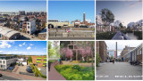
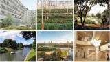
The idea that urban and rural areas should interpenetrate each other is not new. At the time, in Amsterdam it was decided to retain several wedges and to build garden villages. Some of the images in the above collage show such smooth transitions between urban and rural areas: Eko Park, Sweden (top right), Abuja, Nigeria (bottom left), and Xion'an, China (bottom center). The latter two are designs by SOM, an international urban design agency that focuses on biophilic designs.

Pulling nature into the city

Marian Stuiver is program leader Green Cities of Wageningen Environmental Research at WUR. In her just-released book The Symbiotic City, she describes the need to re-embed cities in soil, water and living organisms. An interesting example is a design by two of her students, Piels and Çiftçi, for the urban expansion of Lelystad. The surrounding nature continues into the built-up area: soil and existing waterways are leading; buildings have been adapted accordingly. Passages for animals run between and under the houses (see photo collage, top left). Others speak of rewilding. In this context, there is no objection to a small part of the countryside being given a residential destination. Nature benefits!

Restoration of the rural area

The threat to nature does not come from urban expansion in the first place, but mainly from the expansion of the agricultural area. Don't just think immediately of the clearing of tropical rain woods to produce palm oil. About half of the Dutch land area is intended for cows. Usually, most of them are stabled and the land is mainly used to produce animal feed.
The development of large-scale industrialized agriculture has led to the disappearance of most small landscape features, one of the causes of declining biodiversity. Part of the Climate Agreement on 28 June 2019 was the intention  to draw up the Aanvalsplan landschapselementen . Many over-fertilized meadows and fields that are intended to produce animal feed in the Netherlands were once valuable nature reserves. Today they value from a biodiversity point of view is restricted and they are a source of greenhouse gases. Nature restoration is therefore not primarily focusses at increasing the wooded area. Most of the land can continue to be used for agricultural and livestock farming, provided that it is operated in a nature-inclusive manner. The number of farmers will then increase rather than decrease.

Pulling the city into nature

There are no objections against densification of the city as long this respects the green area within the city. So-called vertical forests by no means make up for the loss of greenery. Moreover, space is needed for urban agriculture and horticulture (photo collage, top center), offices, crafts, and clean industry as part of the pursuit of complete districts. Nature in the Netherlands benefits if one to two percent of the land that is currently used to produce animal feed is used for housing, embedded in a green-blue infrastructure. Some expansion and densification also apply to villages, which as a result are once again developing support for the facilities, they saw disappearing in recent decades.
Finally, I mentioned earlier that nature is more than water, soils, plants, and trees. Biophilic architects also draw nature into the built environment by incorporating analogies with natural forms into the design and using natural processes for cooling and healthy air. The 'Zandkasteel' in Amsterdam is still an iconic example (photo collage, bottom right).
 
Follow the link below to find an overview of all articles.

Herman van den Bosch's picture #Citizens&Living
Herman van den Bosch, professor in management development , posted

21. Work, also in the neighbourhood

Featured image

This is the 21th episode of a series 25 building blocks to create better streets, neighbourhoods, and cities. Its topic is the combination of living and working in the same neighbourhood. This idea is currently high on the agenda of many city councils.  

Benefits for the quality of the living environment

If there is also employment in or near the place where people live, several residents might walk to work. That will only apply to relatively few people, but urban planners think that bringing living and working closer together will also increase the liveliness of the neighborhood. But more reasons are mentioned: including cross-fertilization, sharing of spaces, the shared use of infrastructure (over time), a greater sense of security and less crime. Whether all these reasons are substantiated is doubtful.
In any case, mixed neighbourhoods contributes to widening the range of residential environments and there is certainly a group that finds this an attractive idea. The illustrations above show places were living and work will be mixed (clockwise): Deventer (Havenkwartier), The Hague (Blinckhorst), Leiden (Bioscience Park), Amersfoort (Oliemolenterrein), Amsterdam (Ravel) and Hilversum (Wybertjesfabriek).  

Break with the past

Le Corbusier detested the geographical nearness of work and living. In his vision, all the daily necessities of residents of the vertical villages he had in mind had to be close to home, but the distance to work locations could not be great enough. Incidentally, very understandable because of the polluting nature of the industry in the first half of the 20th century. Nowadays, the latter is less valid. An estimated 30% of companies located on industrial sites have no negative environmental impact whatsoever. A location in a residential area therefore does not have to encounter any objections. The choice for an industrial site was mainly dictated because the land there is much cheaper. And that's where the shoe pinches. The most important reason to look for housing locations on industrial estates is the scarcity of residential locations within the municipality and consequently their high prices. Moreover, in recent decades the surface of industrial estates has grown faster than that of residential locations, at least until a couple of years ago.  

Companies are still hesitating

Companies are generally reserved about the development of housing in their immediate vicinity. Apart from the realistic expectation that the price of land will rise, they fear that this will be at the expense of space that they think they will need to grow in the future. This fear is justified: In the Netherlands 4600 hectares of potential commercial sites disappeared between 2016 and 2021. Another concern is that future 'neighbors' will protest against the 'nuisance' that is inherent to industrial sites, among others because of the traffic they attract. The degree of 'nuisance' will mainly depend on the scale on which the mixing will take place. If this happens at block level, the risk is higher than in case of the establishment of residential neighborhoods in a commercial environment. But as said, there is no need to fear substantial nuisance from offices, laboratories, call centers and the like. Companies also see the advantages of mixing living and working, such as more security.  

Searching for attractive combinations of living and working

Project developers see demand for mixed-use spaces rising and so do prices, which is an incentive for the construction of compact multifunctional buildings, in which functions are combined. To create sufficient space for business activity in the future, they advocate reserving 30% for business space in all residential locations. The municipality of Rotterdam counters this with a 'no net loss' policy regarding gross floor surface for commercial spaces.
Gradually, attractive examples of mixed living and working areas emerge. Park More (from Thomas More), the entrance area of the Leiden Bioscience Park, which will consist of homes, university facilities and a hotel (photo top right). The idea is that in the future there will also be room for the storage of rainwater, the cultivation of food and the production of the estate's own energy.
Another example, which can probably be followed in more places, is the transformation of the Havenkwartier Deventer into a mixed residential and working area, although part of the commercial activity has left and the buildings are being repurposed as industrial heritage (photo above left). The starting point is that, despite hundreds of new homes, the area will retain its industrial and commercial character, although some residents complain about the 'smoothening' of the area'. Living and working remains a challenging combination, partly depending on where the emphasis lies. In this respect, many eyes are focused on the substantiation of the plans of Amsterdam Havenstad.
 
Follow the link below to find an overview of all articles.  

Herman van den Bosch's picture #Citizens&Living
Herman van den Bosch, professor in management development , posted

Expeditie Muziek

Featured image

 
Ik heb de laatste jaren honderden posts geschreven over stedelijke ontwikkeling, innovatie en organisatie. Vele daarvan hebben op deze website gestaan. Ik verschuif mijn schrijfactiviteiten geleidelijk naar het thema waarvan mijn hart sneller gaat kloppen, namelijk muziek.  In mijn nieuwe Nederlandstalige blog 'Expeditie muziek' (zie de link hieronder) verken ik wekelijk een ander facet.  Deze week is dat de geschiedenis van de blues, vorige week heb ik een top tien samengesteld van de in mijn ogen mooiste Nederlandstalige liedjes 'ooit'. Neem eens een kijkje.

Herman van den Bosch's picture #Citizens&Living
Herman van den Bosch, professor in management development , posted

20. Facilities within walking and cycling distance

Featured image

This is the 20th episode of a series 25 building blocks to create better streets, neighbourhoods, and cities. Its topic is to enable citizens having daily necessities in a walking and bicycling distance.

During the pandemic, lockdowns prevented people from leaving their homes or moving over a longer distance. Many citizens rediscovered their own neighbourhood. They visited the parks every day, the turnover of the local shops increased, and commuters suddenly had much more time. Despite all the concerns, the pandemic contributed to a revival of a village-like sociability.

Revival of the ‘whole neighbourhood’

Revival indeed, because until the 1960s, most residents of cities in Europe, the US, Canada, and Australia did not know better than their dally needs were available within a few minutes' walk. In the street where I was born, there were four butchers, four bakers, three greengrocers and four groceries, even though the street was not much longer than 500 meters. No single shop survived. My primary school was also on that street, and you had to be around the corner for the doctor. This type of quality of life went lost, in the USA in particular. However, urban planners never have forgotten this idea. In many cities, the pandemic has turned these memories into attainable goals, albeit still far removed from reality. Nevertheless, the idea of the 'whole neighborhood' gained traction in many cities. It fits into a more comprehensive planning concept, the 15-minute city.

Support for facilities

The idea is that residents can find all daily needs within an imaginary circle with an area of approximately 50 hectares. This implies a proportionate number of residents. A lower limit of 150 residents per hectare is often mentioned, considering a floor area of 40% for offices and small industry. The idea is further that most streets are car-free and provide plenty of opportunity for play and meeting.

Opportunity for social contacts

In a 'whole neighbourhood', residents find opportunity for shopping and meeting from morning to evening. There is a supermarket, a bakery, a butcher, a greengrocer's shop, a drugstore, a handful of cafes and restaurants, a fitness center, a primary school, a medical center, craft workshops, offices, green spaces and a wide variety of houses. Here, people who work at home drink their morning coffee, employees meet colleagues and freelancers work at a café table during the quiet hours. Housemen and women do their daily shopping or work out in the gym, have a chat, and drink a cup of tea. People meet for lunch, dinner and socializing on the terrace or in the cafes, until closing time. A good example is the Oostpoort in Amsterdam, albeit one of the larger ones with a station and a few tram lines.

Planning model

On the map above, the boundaries of the neighborhoods with an area of approximately 50 hectares are shown in the form of circles. The circular neighborhood is a model. This principle can already play a role on the drawing board in new neighborhoods to be built. In existing neighbourhoods, drawing circles is mainly a matter of considering local data. The center of the circle will then often be placed where there are already some shops. Shops outside the intended central area can be helped to move to this area. Spaces between existing homes can be reserved for small-scale businesses, schools, small parks, communal gardens and play facilities. Once the contours have been established, densification can be implemented by choosing housing designs that align to the character of the neighbourhood. Towards the outside of the imaginary circle, the building density will decrease, except at public transport stops or where circles border the water, often an ideal place for higher buildings.

If a thoroughfare passes through the center of the circle, this street can be developed into a city street, including a public transport route. Facilities are then realized around a small square in the center of the circle and the surrounding streets.
Incidentally, space between the circles can be used for through traffic, parks, and facilities that transcend districts, for instance a swimming pool or a sports hall or an underground parking garage. Mostly, neighborhoods will merge seamlessly into each other.
It will take time before this dream comes true.
 
 
Follow the link below to find an overview of all articles.

Herman van den Bosch's picture #Mobility
Herman van den Bosch, professor in management development , posted

19. Safe living environment

Featured image

This is the 19th episode of a series 25 building blocks to create better streets, neighbourhoods, and cities. This post is about increasing the independent mobility of children and the elderly, which is limited due to the dangers that traffic entails.

For safety reasons, most urban children under the age of ten are taken to school. The same goes for most other destinations nearby. It hampers children’s independent mobility, which is important for their development.

Car-free routes for pedestrians and cyclists

For security reasons, car-free connections between homes and schools, community centers, bus stops and other facilities are mandatory (photo’s top left and bottom right). Car routes, in their turn, head to neighborhood parking spaces or underground parking garages. Except for a limited number of parking spaces for disabled people.

Design rules

Model-wise, the design of a residential area consists of quadrants of approximately 200 x 200 meters in which connections are primarily intended for pedestrians and cyclists. There are routes for motorized traffic between the quadrants and there are parking facilities and bus stops at the edges. Inhabitants might decide that cars may enter the pedestrian area at walking pace to load and unload to disappear immediately afterwards. The routes for pedestrians and cyclists connect directly with the shops and other destinations in the neighborhood, based on the idea of the 15-minute city. Shops 'ideally' serve 9 to 16 quadrants. In practice, this mode will have many variations because of terrain characteristics, building types and aesthetic considerations.

Examples

The number of neighborhoods where cars can only park on the outskirts is growing. A classic example is 'ecological paradise' Vauban were 50 'Baugruppen' (housing cooperatives) have provided affordable housing (photo bottom middle ). Car-free too is the former site of the Gemeentelijk waterleidingbedrijf municipal water supply company in Amsterdam - (photo bottom left). Here almost all homes have a garden, roof terrace or spacious balcony. The Merwede district in Utrecht (top middle) will have 12,000 inhabitants and for only 30% room for parking is available, and even then only on the edge of the district. Shared cars, on the other hand, will be widely available. The space between the houses is intended for pedestrians, cyclists and children playing.

More emphasis on collective green

Due to the separation of traffic types and the absence of nuisance caused by car, there are no obligatory streets, but wide foot- and cycle paths. Instead there are large lawns for playing and picnicking, vegetable gardens and playgrounds. Further space savings will be achieved by limiting the depth of the front and back gardens. Instead, large collective space appears between the residential blocks; remember the Rivierenwijk in Utrecht that I mentioned in the former post (top right). Behind the buildings, there is room for small backyards, storage sheds and possibly parking space.
 
Follow the link below to find an overview of all articles.

Herman van den Bosch's picture #Mobility
Herman van den Bosch, professor in management development , posted

18. Space for sporting and playing in a green environment

Featured image

This is the 18th episode of a series 25 building blocks to create better streets, neighbourhoods, and cities. This message is about the limited possibilities for children to play in a green environment because of the sacrifices that are made to offer space for cars and private gardens
 
Almost all residential areas in the Netherlands offer too little opportunity for children to play. This post deals with this topic and also with changing the classic street pattern to make way for routes for pedestrians and cyclists.
Everything previously mentioned about the value of a green space applies to the living environment. The rule 3 : 30 : 300 is often used as an ideal: Three trees must be visible from every house, the canopy cover of the neighborhood is 30% and within an average distance of 300 meters there is a quarter of a hectare of green space, whether or not divided over a number of smaller parcels.

Functions of 'green' in neighbourhoods

The green space in the living environment must be more than a grass cover. Instead, it creates a park-like environment where people meet, it is accompanied by water features and can store water in case of superfluent rain, it limits the temperature and forms the basis for play areas for children.

Legally, communal, and private green areas are different entities; in practice, hybrid forms are becoming common. For example, a communal (inner) garden that can be closed off in the evening or public green that is cadastral property of the residents but intended for public use. In that case the residents live in a park-like environment which they might maintain and use together. Het Rivierdistrict in Utrecht is an example of this.

Play at the neighborhood level

Children want wide sidewalks and a place (at least 20 x 10 m2) close to home that is suitable for (fantasy) games and where there may also be attractive play equipment. The importance of playground equipment should not be overestimated. For many children, the ideal playground consists of heaps of coarse sand, water, climbing trees and pallets. To the local residents It undoubtedly looks messier than a field full of seesaw chickens. Good playground equipment is of course safe and encourages creative action. They can also be used for more than one purpose. You can climb on it, slide off it, play hide and seek and more. Of the simple devices, (saucer) swings and climbing frames are favorites.
A somewhat larger playground to play football and practice other sports is highly regarded. Such a space attracts many children from the surrounding streets and leads to the children playing with each other in varying combinations.

Squares

Most squares are large bare plains, which you prefer to walk around. Every neighborhood should have a square of considerable size as a place where various forms of play and exercise are concentrated. In the middle there is room for a multifunctional space - tastefully tiled or equipped with (artificial) grass - for ball games, events, music performances, markets and possibly movable benches. Ideally, the central part is somewhat lower, so that there is a slope to sit on, climb and slide down. On the edge there is room for countless activities, such as different forms of ball games, a rough part, with climbing trees, meeting places, spaces to hide, space to barbecue and walls to paint, but also catering and one or more terraces. Lighting is desirable in the evening, possibly (coloured) mood lighting. There is an opportunity for unexpected and unforeseen activities, such as a food car that comes by regularly, street musicians that come to visit, changing fairground attractions and a salsa band that comes to rehearse every week.
Such a square can possibly be integrated into a park that, apart from its value as a green space, already offers opportunities for children to play. Adding explicit game elements makes parks even more attractive.

Connecting car-free routes

Safe walking and cycling routes connect playgrounds, parks, and homes. They offer excellent opportunities to use bicycles, especially where they are connected to those of other neighbourhoods.
By seeing facilities for different age groups in conjunction, networks and nodes are created for distinctive target groups. The children's network mainly includes play areas close to home, connected via safe paths to playgrounds in the vicinity. Facilities especially for teenagers are best located somewhat secluded, but not isolated. Essentially, they want to fit in. The teenage network also includes places where there is something to eat, but also various facilities for sports and at a certain age it includes the entire municipality.
 
Follow the link below to find an overview of all articles.

Herman van den Bosch's picture #Citizens&Living