Stay in the know on all smart updates of your favorite topics.
Jip Gradener,
HR
at Pakhuis de Zwijger,
posted
Vacature: Programmamaker Ruimte & Wonen bij Pakhuis de Zwijger
Senior programmamaker Ruimte & Wonen
Creëer jij graag verdiepende, toegankelijke en inspirerende programma’s die de uitdagingen van stedenbouw aansnijden? Begrijp je het belang van samenwerken met verschillende belanghebbenden om rechtvaardige oplossingen te verkennen voor complexe vraagstukken? Kan je je effectief verhouden tot zowel leefwereld (burgers, maatschappelijk middenveld, activisten, NGO’s) als systeemwereld (overheid, kennisinstellingen, bedrijven), om innovatieve programma's te ontwikkelen rondom wonen, ruimtelijke ordening en duurzaam, creatief en inclusief bouwen?
Solliciteer dan nu voor de functie van senior programmamaker Ruimte & Wonen bij Pakhuis de Zwijger.
Full-time · Pakhuis de Zwijger
Over Pakhuis de Zwijger
Pakhuis de Zwijger maakt meer dan 600 programma’s per jaar over dringende maatschappelijke vraagstukken, met rechtvaardigheid als kernwaarde. We brengen belanghebbenden samen in verschillende formats om gezamenlijk oplossingen te verkennen. Dit doen we met een team van programmamakers, producenten, communicatiemedewerkers en technici.
Wat zoeken we?
Een creatieve en daadkrachtige programmamaker met inhoudelijke kennis van stedenbouw en ruimtelijke ordening. Je hebt het vermogen om effectief te schakelen tussen verschillende belanghebbenden, van lokale gemeenschappen tot zakelijke partners, om vernieuwende programma's te ontwikkelen die het publiek bewust maken van stedelijke en ruimtelijke vraagstukken en transities verder helpen.
Als senior programmamaker draag je bij aan de strategische ontwikkeling van de programmering. Je initieert en onderhoudt partnerschappen, werkt aan opdrachten en stuurt enkele programmamakers en stagiairs aan op jouw thema. Enige ervaring met leidinggeven aan een (klein) team is dus een pré. Door kennis en presentatie heb je inhoudelijk gezag in je werkgebied.
Jouw profiel:
- Actuele kennis en een stevig netwerk op het gebied van ruimtelijke thema’s.
- Strategisch inzicht; ervaring met het onderhouden van samenwerkingsverbanden en het aantrekken van nieuwe (financiële) partners.
- Creatief, leergierig en vol met originele ideeën.
- Communicatief sterk (zowel intern als extern) en cultureel sensitief. Je hebt een sterk vermogen om je in anderen te verplaatsen.
- Beschikbaar voor 40 uur per week waarvan gemiddeld één avond per week voor het draaien van een programma.
Bij Pakhuis de Zwijger hanteren we de CAO Nederlandse podia. Deze functie is ingeschaald in schaal 7 (minimum €3.516 en maximum €4.940), de precieze inschaling is afhankelijk van ervaring en kwalificaties.
Pakhuis de Zwijger is een cultureel-maatschappelijke non-profitorganisatie. Wij streven er naar een grote diversiteit aan identiteiten en ervaringen de ruimte te geven in ons team. Daarom moedigen wij nadrukkelijk mensen van alle culturele en genderidentiteiten en opleidingsachtergronden aan om te solliciteren.
Geïnteresseerd?
Solliciteer vóór maandag 13 mei 2024 via de onderstaande link. Voor vragen kun je contact opnemen met HR-adviseur Jip Gradener via: 06-13626126.
Acquisitie naar aanleiding van deze oproep wordt niet op prijs gesteld.
Timo van Elst,
Student
at Amsterdam University of Applied Sciences,
posted
Demoday #23: Mobility Injustices and the creative mind.

In a world where moving yourself from point A to point B is becoming much more crucial than ever, there are people out there who cannot experience such a luxury at the flick of a wrist, or perhaps the clack of an ankle? It is hard to imagine sometimes, but there are those who cannot move around as easily as others; be it because of financial, physical, vehicular, or other reasons. A community that can go about as they please without any issues is a happy community that is beneficial to society – For a collective of governments and businesses it is in their best interests to ensure citizens can experience freedom and liberty in their mobility. The question of how to achieve this freedom in mobility and how to deter against injustices regarding mobility remains a hot topic, however. On behalf of Provincie Noord Holland and in collaboration with Amsterdam Smart City and Amsterdam Centre of Expertise, a group of graduating students tackled this topic on the latest Demoday of 2024.
Starting the voyage : What are mobility injustices?
A value workshop led by Jackie Ippel and Jade Salomons engaged the participants in a fun, creative wave of brain-crackling activities. Participants were presented with a question of whether they knew what mobility injustices, or as we call it in Dutch “Mobiliteits Armoede”, was. An explanation of which followed suit soon after. Mobility Injustices, as described by the KiM organization, explains the inability or difficulties people experience in terms of reaching activity locations due to inadequate transport options, combined with socio-economic and spatial conditions in which people find themselves. As a result, they are often hindered in their participation in social life, which negatively affects their quality of life.
It is important to think about the definition of what exactly mobility injustices entail, as it helps us find a better understanding in finding a creative series of solutions that will solve this complex jigsaw puzzle.
Like a ball of yarn : unraveling theorems.
In order to stimulate the brain of each participant and to get the blood pumping through their legs, each participant was asked to stand in the middle of the room. As was once quoted in the horror thriller Saw; “Wanna play a game?”. Participants were presented with a series of theorems in which they had to make a choice that’d question their liberal thoughts; either stand on one side of the room for one answer or on the other side for the other – No in-betweens. Being forced to make ultimatums proved to be both challenging for the participants yet fun, as it was met with bountiful heaps of enthusiasm. In the first theorem, participants were presented with a question of whether or not mobility should be a fundamental right for each and every citizen. While agreed one did not, but can their minds be changed? A flurry of other theorems were presented, each of which dove deeper into the depths of dilemmas one may encounter when attempting to solve the puzzle of mobility inequality. Like who is more important, those who have low incomes or those who suffer from physical and mental disabilities which hinder their day-to-day lives? Brief discussions flowed forth after each and every theorem, after each voting round, reasons were given as to why one can choose one over the other. After which another second voting session followed. Perhaps new insights would change one’s opinion on the subject? It actually did once or twice! Such is the power of dialogue.
Embarking into the abyss : Worst Idea Possible.
“How ba-a-a-ad can I be? I’m just doing what comes naturally-“ -such were the words Onceler sung in Dr. Seuss’s ‘The Lorax’. While people do not like the idea of being bad or thinking of bad ideas sometimes this way of thinking can actually bring plentiful new insights never thought of before. The group split itself in two, each of which under the guidance of either Jackie Ippel or Jade Salomons. Participants were asked to come with their most horrid, ludicrous ideas that’d actually make mobility injustices worse. After which they had to decide what element made this a bad idea. Example, if public transport were to be described, the element that’d make the idea bad would be less alternatives for traveling. The final and third part of this exercise required something rather unique however. Does your mind already wonder what? Well, it’s quite simple really, now participants had to come up with what would be the opposite of their bad idea! So what would their idea be in reverse, an actual solution to the problem they created. If your bad solution was to make everything only scannable by QR-codes its reverse solution would be… using solely physical text! For a solid 20 minutes participants racked their heads and discussed until their times were down to only 5 minutes left. The last of those minutes left were spent discussing and laughing about their ideas – A method met with confusion at first was appreciated with loads of enthusiasm by the end where only time was the fun killer.
A creative view found in madness: Crazy Eight.
The creativity cannot just end after one session. Holding the thought of the previous session, participants were asked to gather in a circle around a table. With each given a paper and asked to fold it so that 8 separate square spaces would form on the sheet the Crazy Eight exercise was explained. Participants were asked to draw their solution one of their 8 square. For each drawing they had a minute per square, a total of 8 minutes until all were filled. Of course with so little time there was little room for thinking, imagination had to pull the cart here, which led to both silly and unique drawings. The longer the session went on the more difficult it became – the participants were truly pushed to their creative limits. A well-trained eye could even notice how some participants still tried to finish their previous drawing before moving onto the next despite the time. You could feel the atmosphere in the room shift to a hectic, almost crazy aura, thus doing its name of ‘Crazy Eight’ truly justice.
At the end of the session it was only natural that people presented their top 3 drawings. One after another each participant proudly showed off their creative drawings like a trophy to the rest of the group. Turns out, despite not communicating with one another during the drawing sessions there were lots of similarities in the elements used in each drawing. The bus, the civil servant, and the elderly were commonly used elements seen back in almost everyone’s drawing. Via these sources of inspiration it became clear just where the solutions may lie.
An journey’s end : Results.
At the end of the session we didn’t just start talking about what we had done. No, instead we At the end of the session, we didn’t just start talking about what we had done. No, instead we went back and looked at the very first theorem everyone was presented with; “Should mobility be a fundamental right for each and every citizen?”. Last time everyone answered all but one was in favor of this theorem, now participants were asked to revise their statement and see if they still agreed with what they said at the beginning. As said before, dialogue can change the outlook we have on the world and so someone did change their stance – The one person that disagreed with the theorem now actually agreed that mobility should be a fundamental right. A full 100% score! Only after this a talk about what we had done started. Opinions were asked and each participant shared the emotion they had experienced during this work session and to leave it behind on a post-it.
· Fun and insightful: The gamification of thinking is taking the design world by storm, and on this Demoday, it has proven that this form of design thinking can not only be effective in bringing brand new insights but also can be fun.
· Enthusiasm: What started off with an iffy approach ended with tons of enthusiasm. Idea generating doesn’t just have to be sitting at a table and talking in your own bubble; it can become so much more effective when the mood is changed from serious and gloomy to frivolous and enthusiastic..
· Creativity: A creative way of thinking actually helps in generating ideas. Using playful thinking such as considering a bad idea first and then the opposite helps find solutions to problems in a much more efficient way.
During this Demoday, we as a group of graduating students got to know the thought process behind those who work within the field of mobility. While we hope that we brought them plenty of insights and, above all, a fun day, it is sufficient to say that we too learned an abundance of information. The insights made during the Demoday will be used by us in writing our final report for the Provincie Noord Holland regarding a detailed consult on how to improve the mobility of the citizens of the province of Noord-Holland and how to tackle the injustices surrounding mobility. Demoday’s are fun and can inspire even the most closed-minded people. If we could, we would do it all over again. And, if you are still on the fence about joining a Demoday, then I hope that column will ignite that curiosity.
Herman van den Bosch,
professor in management development
,
posted
The global distribution of the 15-minute city idea 5/7
A previous post made it clear that a 15-minute city ideally consists of a 5-minute walking zone, a 15-minute walking zone, also a 5-minute cycling zone and a the 15-minute cycling zone. These three types of neighbourhoods and districts should be developed in conjunction, with employment accessibility also playing an important role.
In the plans for 15-minute cities in many places around the world, these types of zones intertwine, and often it is not even clear which type of zone is meant. In Paris too, I miss clear choices in this regard.
The city of Melbourne aims to give a local lifestyle a dominant place among all residents. Therefore, everyone should live within at most 10 minutes' walking distance to and from all daily amenities. For this reason, it is referred to as a 20-minute city, whereas in most examples of a 15-minute city, such as Paris, it is only about <strong>the round trip</strong>. The policy in Melbourne has received strong support from the health sector, which highlights the negative effects of traffic and air pollution.
In Vancouver, there is talk of a 5-minute city. The idea is for neighbourhoods to become more distinct parts of the city. Each neighbourhood should have several locally owned shops as well as public facilities such as parks, schools, community centres, childcare and libraries. High on the agenda is the push for greater diversity of residents and housing types. Especially in inner-city neighbourhoods, this is accompanied by high densities and high-rise buildings. Confronting this idea with reality yields a pattern of about 120 such geographical units (see map above).
Many other cities picked up the idea of the 15-minute city. Among them: Barcelona, London, Milan, Ottawa, Detroit and Portland. The organisation of world cities C40 (now consisting of 96 cities) elevated the idea to the main policy goal in the post-Covid period.
All these cities advocate a reversal of mainstream urbanisation policies. In recent decades, many billions have been invested in building roads with the aim of improving accessibility. This means increasing the distance you can travel in a given time. As a result, facilities were scaled up and concentrated in increasingly distant places. This in turn led to increased congestion that negated improvements in accessibility. The response was further expansion of the road network. This phenomenon is known as the 'mobility trap' or the Marchetti constant.
Instead of increasing accessibility, the 15-minute city aims to expand the number of urban functions you can access within a certain amount of time. This includes employment opportunities. The possibility of working from home has reduced the relevance of the distance between home and workplace. In contrast, the importance of a pleasant living environment has increased. A modified version of the 15-minute city, the 'walkable city' then throws high hopes. That, among other things, is the subject of my next post.
Make this your personal feed
Steven Conderaerts,
data driven company in dynamic parking bay mgmt
at geosparc,
posted
Visit us at Intertraffic Amsterdam at booth 10.336
Discover our solutions for disabled parking management (as installed in Breda), management for electrical charging on public loading infrastructure and shop&go parking spots.
Tom van Arman,
Director & Founder
at Tapp,
posted
Opening exhibition: Urban Sky Lab – Designing for drones in the city
Last month designers FABRICations, Studio To Create and Inbo the question: “How can drones create a more livable Amsterdam?” The teams developed near-future design scenarios were emergency response and delivery of goods (and people) would impact project areas the Western Port Area, Amsterdam Zuidoost, and RAI Amsterdam. Project partners Arcam and the Amsterdam Drone Lab invite you to the “Urban Sky Lab” expo which kicks off with an actual drone flying from Marineterrein to the ARCAM building to open the expo. Curious about the design proposals? or how this new low altitude airspace above our city will work? Join us!
Title: Opening Exhibition Amsterdam Urban Sky Lab
Date: Thursday, March 28, 2024
Time: walk-in from 5 p.m. – end around 7 p.m.
Location: Arcam
Address: Prins Hendrikkade 600
Sign up for the opening: https://forms.gle/GTNfDBNdUfqA2fhJ6
Jose M. Rodrigo,
CMO
at Mobypark,
posted
Exploring Smart Parking Solutions in Amsterdam: The Role of Mobypark in Shaping Urban Efficiency
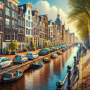
The quest for parking in Amsterdam presents a unique set of challenges, including narrow lanes, constant vehicular flow, and strict parking policies. This iconic city, celebrated for its canal system, historical buildings, and cultural vibrancy, also faces the modern urban dilemma of parking scarcity. Amidst these challenges, Amsterdam's approach to parking, characterized by a zonal system with variable rates, mirrors its commitment to promoting sustainable urban mobility. Within the bustling heart of the city, parking fees can soar to €7.50 per hour, a pricing strategy designed to incentivize public transport and biking, cherished and eco-friendly travel methods among the locals.
Amsterdam's dynamic parking strategy also paves the way for innovative solutions like Mobypark, a platform revolutionizing parking by facilitating the rental of private parking spots. This initiative not only offers a cost-effective alternative to the traditional parking hunt but also optimizes the use of existing spaces, aligning with the city's sustainability goals.
For those seeking affordability without sacrificing convenience, Amsterdam's Park and Ride (P+R) facilities serve as a beacon. Strategically located at the city's periphery, these parking havens offer reduced rates, encouraging drivers to park their vehicles and hop on public transport to reach the city's core. This system significantly mitigates urban congestion and lowers parking costs for both tourists and daily commuters.
The allure of P+R locations is undeniable, especially when juxtaposed with the exorbitant costs of street parking. To access P+R discounts, users must integrate their parking with public transportation, highlighting the city's efforts to weave sustainability into the fabric of urban travel. Mobypark's P+R options stand out for their simplicity and affordability, offering seamless access to the city center without the usual prerequisites. Examples include:
Amsterdam's strategy to curtail on-street parking availability is a deliberate move towards fostering a more sustainable, pleasant cityscape. By endorsing alternatives like public transport, cycling, and Mobypark's innovative parking solutions, Amsterdam is making strides in reducing traffic jams, cutting down on pollution, and improving urban life quality. These initiatives are testament to Amsterdam's dedication to a sustainable future, highlighting Mobypark's pivotal role in transforming the city into a smarter, more navigable urban space.
Find a link to Mobypark here: Amsterdam parking
Mark Stoevelaar,
Project manager
at City of Amsterdam: Digitalization & Innovation,
posted
Are you an innovative entrepreneur? The In Residence Open Events program might be your chance to cooperate with Amsterdam!

Want to test your innovation during an open event such as Amsterdam Pride or the Amsterdam marathon? And looking for the opportunity to cooperate with the city in the long run?
The In Residence Open Events programme might be something for you. We have 8 broad defined challenges, ranging from circular economy to safety, from mobility to extreme whether. Basically we're looking for all innovations that can have an positive impact on the city and the event of the future!
During the programme you get:
- The opportunity to pilot your solution at an open event in Amsterdam, such as Amsterdam Pride or the Amsterdam Marathon
- 15K test budget to execute this pilot
- Guidance by an experienced mentor
- Access to the large municipality network
- The opportunity for long term cooperation in case of a succesfull pilot
- Large exposure and feedback opportunities
Interested to see our programme, the challenges and opportunity this brings for you?
See our website, www.innovatiepartners.nl, or see most recent LinkedIn post: https://www.linkedin.com/posts/gemeente-amsterdam-innovatie_inresidence-amsterdam-innovatie-activity-7163881081757253632-6soh?utm_source=share&utm_medium=member_desktop
For questions or thoughts, you can reach out to Mark Stoevelaar, project manager of the In Residence programme.
- mark.stoevelaar@amsterdam.nl
- +31621193028
Paul HOLMES,
Entrepreneur
,
posted
Revolutionise Recycling, Redefine Wealth: Seize the Opportunity with ByeBye Bed Limited and Reborn Products!

Greetings Trailblazing Visionaries,
Get ready for a seismic shift in sustainability! We're ByeBye Bed Limited, a force of innovation since 2019, experiencing a staggering 900% growth, and now we're inviting you to be part of our electrifying journey - Reborn Products.
The Powerhouse Behind ByeBye Bed Limited: Meet Paul Beckett, the maverick entrepreneur who saw a goldmine in recycling. His vision isn’t just about mattresses; it’s about transforming waste into a treasure trove of sustainable, retail-worthy products. The world is ready for this revolution, and we're leading the charge.
Dazzling Growth, Unstoppable Momentum: From a modest 6,000 sq. ft. to our current 60,000 sq. ft. facility, we've supersized our operation to revolutionise recycling on a grand scale. Brace yourself for a dedicated manufacturing facility that will catapult our capabilities into the stratosphere.
Reborn Products: Where Sustainability Meets Luxury: Our 'Reborn' products aren't just eco-friendly; they're a testament to style, comfort, and sustainability. From avant-garde mattresses to chic futon chairs and everything in between, we’re turning waste into opulence. Currently, 96% of our materials are recycled, making us the pinnacle of green innovation.
Crushing the Landfill Crisis: We're not just talking the talk; we're walking it, stomping on the UK landfill crisis that swallows almost 5,000,000 mattresses each year. We're not just recycling; we're redefining waste, turning it into a jaw-dropping spectacle of sustainability.
Financial Dynamo: Fueling the Future: Hold on tight because the next phase is a financial thunderstorm. We're not just enhancing the use of our recycled materials; we're rewriting the rules of industry, starting with furniture making. Imagine a world where our waste stream becomes the lifeblood of innovation.
Revolutionary Padding Material: Unleashing the Future: Introducing our game-changing padding material, birthed from our waste streams. It's not just 100% recyclable; it's a disruptor, challenging the status quo and reshaping the very fabric of eco-friendly living.
Invest in Tomorrow: ByeBye Bed Limited is the Future: This isn’t just a crowdfunding opportunity; it’s your ticket to invest in the future of sustainability. Join the movement, fuel the revolution, and be part of a success story that will be told for generations.
Social Impact: Building Lives, Breaking Chains: But wait, there's more! Our initiative with HMP isn’t just about recycling materials; it's about recycling lives. We're rehabilitating prisoners, re-skilling them for a triumphant return to society. And the best part? They potentially become integral members of our powerhouse workforce.
Your Invitation to Greatness: Investing in ByeBye Bed Limited and Reborn Products isn’t just about returns; it’s about being part of a seismic shift. This is your opportunity to be on the ground floor of something monumental.
Interested in More Details? Ignite the Revolution - Join Us Now: Email us for more details and become part of a future where recycling isn’t just responsible; it’s a lifestyle. Let's redefine waste, together.
Thank you for daring to dream big with ByeBye Bed Limited and Reborn Products.
Tom van Arman,
Director & Founder
at Tapp,
posted
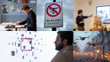
Urban Sky Lab - How do drones fit into the city of tomorrow?

The air space above our city is about change. Drones will soon have a profound impact on our collective future - Last year alone, the city of Amsterdam detected over 43,000 low-altitude flights over our parks, squares, and waterfronts. As this trend continues to grow year-after-year, how can we repurpose drones to create a more sustainable and livable city?
This Thursday & Friday (15-16 Feb.) we are hosting the Urban Sky Lab together with Arcam and the Amsterdam Drone Lab. For this unique event we have invited Studio To Create, INBO, and FABRICations into a two-day sprint to design a future with drones for the Western Docklands, Amsterdam Zuidoost (Amsterdamse Poort area) and RAI Amsterdam.
You are welcome to attend the presentations of the preliminary results at Hotel Casa Amsterdam on Friday afternoon 16 February.
Naomi Vrielink,
Projectmedewerker
at Future City Foundation,
posted
Slimme Stad Parade 23 mei 2024

Er zijn zoveel smartcity-onderzoeken dat je soms de bomen door het bos niet meer ziet. En daarom brengen we op 23 mei 2024 in Utrecht alle bomen bij elkaar. Wil je weten welke innovatieve smartcity-onderzoeken er zijn die bijdragen aan een leefbare en slimme en sociale stad? Dan mag je de Slimme Stad Parade op 23 mei in het provinciehuis van Utrecht niet missen!
Tijdens dit unieke evenement krijg je de kans om kennis te maken met alle smartcity-onderzoeken in Nederland en Vlaanderen. Ontdek welke slimme wetenschappelijke onderzoeken er zijn voor het sociaal domein en hoe we de verstedelijkingsopgaven van de toekomst kunnen oppakken. En leer wat digitalisering en technologisering betekent voor de maatschappelijke opgaven van vandaag.
Dus, wil je weten welke smartcity-onderzoeken er zijn die bijdragen aan een betere wereld? Wil je het hele bos kunnen overzien? Kom dan naar de Slimme Stad Parade op 23 mei in het provinciehuis van Utrecht en laat je inspireren!
Programma (wijzigingen voorbehouden):
Programma (wijzigingen voorbehouden):
10.00 – Inloop
10:30 – Welkom bij de Slimme Stad Parade
10:40 – Dank voor de gastvrijheid
10:50 – Welkom in de Provincie Utrecht bij de Data en Kennishub Gezond Stedelijk Leven – Henri de Ruiter (DKH Gezond Stedelijk Leven)
11:00 – Pauze en zaalwissel
11:05 – 11:45 – Verdieping
In de Verdiepingszaal gaan we dieper in op de volgende stap van pitches 11, 12, 13 en 14. We focussen in dit blok op het thema bestuur en organisatie.
11:05 – Monitoringsprogramma Cartesius – Pitch 1 – Marije Lammers (Universiteit Utrecht)
Het monitoren van de effecten van interventies in de leefomgeving (fysiek, sociaal en zorg) op de gezondheid en het welzijn van bewoners in Cartesius, een gebied waar ontzettend veel belangrijke thema’s samenkomen (beweging, voeding, duurzaamheid, sociale cohesie etc.), maar ook waar veel verschillende partijen en expertises samenkomen op het gebied een gezonde leefomgeving. En waar de effecten van interventies en ontwerpkeuzes uitgebreid gemonitord gaan worden, als opzet voor een landelijk monitoringsprogramma.
11:20 – Emeralds: Extreme-scale Urban Mobility Data Analytics as a Service – Pitch 2 – Sascha Hoogendoorn-Lanser MICD (TU Delft)
Steden beschikken vaak over veel gegevensbronnen over verkeersopstoppingen. De verwerking, analyse en het gebruik (bijv. voor context-afhankelijke voorspelling) wordt echter belemmerd door het gebrek aan toepasbare methoden en extreme dataverwerkingstools. EMERALDS zal deze uitdaging aangaan.
11:35 – GROUNDED in de Kien: Stadscampus Deventer – Pitch 3 – Meike Heijenk (Saxion)
De SPRONG-groep GROUNDED van lectoren van Saxion en De Haagse Hogeschool richt zich op het samengestelde, elkaar versterkende, inzicht van boven- én ondergrond. Van wonen en werken én de grond daaronder die we gebruiken voor landbouw, kabelwerk en opslag (legaal en illegaal). Informatie die antwoorden geeft op urgente vraagstukken voor steden en dorpen, ons omgaan met het klimaat en de ruimte voor duurzame energie, natuur en recreatie.
11:50- Pauze en zaalwissel
12:05 – 12:50 – Verdieping
In de Verdiepingszaal gaan we dieper in op de volgende stap van pitches 1, 2 en 3. We focussen in dit blok op het thema betere leefomgeving door gebruik van data.
12:05 – Inwoners betrekken bij hun leefomgeving door het gebruik van een digital twin – Pitch 4 – Arjun Snoep-Dellema (Gemeente Arnhem)
Binnen de gemeente Arnhem is onderzocht hoe digital twin toepassingen (bv. Virtual Reality of ArcGIS) ingezet kan worden bij projecten binnen de fysieke leefomgeving met burgerparticipatie. We zijn bij drie verschillende projecten aangesloten om de verschillen op het gebied van mobiliteit, woningbouw en vergroening via digital twin toepassingen beter inzichtelijk te maken aan inwoners. De hoofdvraag van het onderzoek luidt: In hoeverre zorgt het inzetten van digital twin toepassingen voor toegevoegde waarde binnen projecten van de gemeente Arnhem, en in het bijzonder bij projecten binnen de fysieke leefomgeving met een participatietraject?
12:20- Digital Society and the Quality of Urban Space – Pitch 5 – Paul Rutten (Hogeschool Rotterdam)
In het project Digital Society and the Quality of Urban Space staat de vraag centraal welk digitalisering heeft op de kwaliteit van leven in steden? Hoe beïnvloedt digitalisering gebruik en inrichting van stedelijke ruimte? Welke impact heeft digitalisering op publieke waarden in de stad? Hoe verschillen publieke digitale diensten daarin van commerciële? Wat is de rol en betekenis van bewoners en lokale overheden? Wat zijn de belangrijkste ontwikkelingen voor de toekomst?
12:35- Fijnstofonderzoek met scholieren op de snuffelfiets – Pitch 6 – Dorien Dorresteijn (GLOBE Nederland)
GLOBE Nederland zet projecten op, zodat leerlingen van middelbare scholen door heel Nederland meten aan hun leefomgeving. Zo maken ze bijvoorbeeld gebruik van de snuffelfiets om de fijnstof in kaart te brengen. In de provincie Utrecht doen al 22 scholen mee. We werken bij dit project samen met het RIVM en verschillende gemeentes en provincies, waaronder de provincie Utrecht.
12:50 – Netwerklunch
13:30 – Lezing na de lunch: Zo gebruik je kennis in je organisatie
Met ruim 10 jaar ervaring bij het Groene Brein weet Antoine Heideveld ondertussen wel hoe je wetenschap en onderzoek kan toepassen in je organisatie. Die inzichten deelt hij met ons.
14:00 – Pauze en zaalwissel
14:10 – 15:10 – Verdieping
In de Verdiepingszaal gaan we dieper in op de volgende stap van pitches 4, 5 en 6. We focussen in dit blok op het thema betrekken van belanghebbenden.
14:10- Digitale veiligheid van smartcitysystemen – Pitch 7 – Willem Bantema (NHL Stenden Hogeschool)
Hoe digitaal veilig zijn gemeentelijke smart city toepassingen en welke concrete oplossingen en oplossingsrichtingen dragen bij aan het verbeteren van de digitale veiligheid van deze toepassingen?
14:25 – AI Compass: Adaptive Intelligence in Crowd Crisis Management through Al-Human Coordination and Ethical Practice – Pitch 8 – Sascha Hoogendoorn-Lanser MICD (TU Delft)
De combinatie van complexiteit, tijdsdruk en morele beslissingen is een flinke uitdaging in crisissituaties. Ai heeft een enorm potentieel om beslissingen bij crowd crises te ondersteunen. Het AI-COMPASS consortium, onder leiding van TU Delft, ontwikkelt real-time ondersteuningssystemen die rekening houden met context, gedrag en waarden.
14:40 – Moral Smart City – Pitch 9 – Jeroen de Vos (Fontys)
We bouwen in het Moral Smart City onderzoek aan een genuanceerde strategie om een breed debat te voeren over Slimme Stedelijke ontwikkelingen en inclusieve besluitvorming te bevorderen. Dit doen we door stedelijke ethische commissies, burgerparticipatie, lokale bestuursorganen en mediaorganisaties uit zeven Nederlandse steden aan elkaar te koppelen. We focussen hierbij op journalisten in –met name lokale – media willen graag de rol van ‘vierde macht’ vervullen rondom techno-ethische thema’s, maar vooralsnog ontbreekt het hen aan handvatten om dit op een meer verdiepende publieksgerichte manier te doen.
14:55 – AI ELSA-Lab Noord-Brabant – Pitch 10 – Ben Kokkeler (Avans Hogeschool)
Het AI ELSA-Lab Noord-Brabant is een innovatief samenwerkingsplatform waarin we toegepast onderzoek verrichten en kennis ontwikkelen met de burger, overheidsorganisaties en ondernemers als middelpunt. Het is een is een internationaal beproefde en wetenschappelijk onderbouwde methode om de ethische, juridische én maatschappelijke impact van concrete technologische toepassingen integraal te beoordelen. Deze geïntegreerde manier van kijken brengt kansen en risico’s in beeld, tijdens het ontwikkelproces en tijdens de invoering van AI toepassingen. Het disruptieve karakter van AI vraagt om nieuwe manieren van samenwerken. Hoe pak je dat als gemeente verantwoord aan in samenspel met burgers en ondernemers?
15:10 – Pauze en zaalwissel
15:25 – 15:25 – Verdieping
In de Verdiepingszaal gaan we dieper in op de volgende stap van pitches 7, 8, 9 en 10. We focussen in dit blok op het thema ethiek.
15:25 – Citizen Science projecten in de provincie Utrecht – Pitch 11 – Arjen Hof (Good City Sense)
De provincie Utrecht is koploper als het gaat om citizen science projecten, zoals Snuffelfiets, Telraam en Pientere Tuinen. In het onderzoek combineren we de ervaringen uit deze projecten tot een integrale aanpak.
15:40 – LIVE – Pitch 12 – Leon Hendriks (AeroVision)
Project LIVE heeft onderzocht en aangetoond dat door het combineren van diverse data een integraal beeld ontstaat dat helpt bij de besluitvorming. Door (beoogde) aanpassingen en scenario’s in de fysieke leefomgeving vooraf zichtbaar te maken in een 3D-omgeving, kan de impact op de leefbaarheid, waterhuishouding, biodiversiteit en zelfs woongeluk in beeld worden gebracht. Een slimme tool om afgewogen de juiste beslissingen te nemen en elke vierkante meter optimaal te benutten.
15:55 – De slimme, duurzame stad in beeld – Pitch 13 – Mike van Dijk en Sonja Hulshoff ( Ministerie van Infrastructuur en Waterstaat)
Hoe operationaliseren we de blauwdruk van de G40 Smart City Groep ‘Slimme, duurzame verstedelijking en mobiliteitsvernieuwing’ naar een integraal dashboard van een stad, gebied of opgave? Slimme, duurzame verstedelijking en mobiliteitsvernieuwing raakt meerdere domeinen: ruimtelijke ontwikkeling/inrichting, wonen, energie, verkeer en mobiliteit, gezondheid, bouw, logistiek etc. Ieder domein kent zijn ambities, doelstellingen, indicatoren, richtlijnen, en data. Maar welke indicatoren zijn echt van belang voor besluitvorming van gemeenten en laten zien hoe een stad functioneert? Welke data, interoperabiliteit, informatie en toepassingen helpen bij het inzichtelijk maken en realiseren van de doelen op straat? Welke stad of gemeente kun je zijn? Het DMI-ecosysteem onderzoekt hoe dit beeld te operationaliseren.
16:10 – Dit was de City Deal ‘Een slimme stad, zo doe je dat’ – Pitch 14 – Jan-Willem Wesselink (Future City Foundation)
Na 5 jaar samenwerken wordt de City Deal in 2024 afgerond. Wat zijn de resultaten en hoe worden die geborgd in het DMI-ecosysteem?
16:25 – Afsluiting en einde
16:30 – Netwerkborrel
__________________________________________________
Datum: 23 mei 2024, 10.00 – 17.00 uur (inloop 10.00- 11.00 uur).
Locatie: Provinciehuis Utrecht
Kosten: Deelname aan de Slimme Stad parade is gratis
Meld je hieronder aan:
Herman van den Bosch,
professor in management development
,
posted
5. Driving without a driver has a price
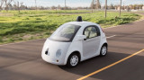
In an autonomous car from SAE level 4, perception equipment – the eyes and ears – and software take over human brain functions. This requires accurate maps, laser, radar, lidar and cameras. The lidar, which means 'detect light and range', works in conjunction with the car's cameras. This system pulses laser waves to map the distance to objects day and night, up to up to 100 meters with an accuracy of a few centimeters. The price of all this equipment is between €150,000 and €200,000. The lidar is a high-cost item, although this system is becoming increasingly cheaper due to industrial production. Together, these tools build a four-dimensional image of the environment, and all functions of the moving car are controlled using stored software and communications in the cloud.
Google/Waymo
Google's X-lab began developing an autonomous car in 2009. In 2016, the company had already completed more than 1.5 million test kilometers and spent $1.1 billion on the development of an autonomous car. The company previously used a self-developed model ('the firefly', see photo). The company then deployed converted Chrysler Pacifica Hybrids, and these will be exchanged for fully electric Jaguar I-Pace cars.
In 2016, Google's parent company Alphabet parlayed autonomous car developments into a new company called Waymo (derived from "a new way of mobility").
General motorcycles/cruise
Cruise was founded in 2013 with the intention of developing a self-driving car. In 2016, General Moters acquired the company for an amount of $500 million. To date, the company has completed 700,000 test miles in San Francisco's urban environment with no fatalities.
Uber
In 2016, Uber began working with Volvo to develop an autonomous car that could serve as a taxi. The company had acquired software manufacturer Otto for a net $600 million. The company predicted that there will be 75,000 self-driving cars on the road by 2019. That became zero. During the test phase, the company experienced several accidents, including one with a fatal outcome. In addition, Waymo became a target of data theft, a case that was decided in Waymo's favor by the court. Uber therefore had to pay damages of €250 million (in shares). This led to the departure of Uber founder Travis Kalanick. His successor, Dara Khosrowshahi, has put the development of an autonomous car on the back burner. It was recently announced that Uber has signed a contract with Waymo to use this company's autonomous cars in the future.
Tesla
Until recently, the use of lidar was not possible due to the high costs for car manufacturers that opt for accreditation at SAE level 3. Tesla therefore equipped its cars exclusively with radar, cameras and computer vision. The latter means that all driving Teslas transmit camera images of traffic and the way in which motorists react to 'the cloud'. The company has been developing these images with artificial intelligence for years. It prides itself on the fact that its cars have rules of conduct for every conceivable traffic situation.
The development of the Tesla was accompanied by high expectations but also by many accidents, some of which were fatal. Last year, Tesla made available a beta version of the FSD ("Full Self Driving") software package for a price of $15,000. However, the company had to recall as many as 362,000 cars under the authority of the Traffic Safety Administration because this package was encouraging illegal driving. It looks like that these issues have been resolved and some experts have suggested that Tesla will be able to qualify for accreditation at least at SEA Level 3. This still has to happen.
Ford and Volkswagen
These companies threw in the towel in 2022 and unplugged Argo, a company that was supposed to develop an autonomous car to provide SAE level 4 taxi services. Instead, both companies announced focusing on the SAE levels 2 and 3, like most auto makers.
According to analysts at AlixPartners, the industry has invested $100 billion in developing car automation by 2023, in addition to $250 billion in development of electric cars. I will discus the profitability of these investments later.
Herman van den Bosch,
professor in management development
,
posted
Why we should stop talking about self-driving cars (3/8)
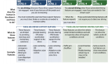
The term 'self-driving car' is used for a wide variety of technical support systems for car drivers. The Society of Automotive Engineers (SAE) has distinguished six types, as mentioned in the tabel above. This classification is recognized worldwide.
At SAE level 0, a car has been equipped with various warning systems, such as unvoluntary deviation from lane, traffic in the blind spot, and emergency braking.
At SEA levels 1 and 2, cars can steer independently or/and adjust their speed in specific conditions on motorways. Whether drivers are allowed to take their hands from the steering wheel depends on national law. That is certainly not the case in Europe. As soon as environmental conditions make steering and acceleration more complex, for example after turning onto a busy street, the driver must immediately take over the steering.
A properly functioning SAE Level 3 system allows drivers to take their eyes off the road and focus on other activities. They must sit behind the wheel and be on standby and are always held responsible for driving the car. They must immediately take over control of the car as soon as 'the system' gives a ('disengagement') signal, which means that it can no longer handle the situation. There is currently no car worldwide that is accredited at SEA-3 level.
This level of control is not sufficient for driverless taxi services. Automotive and technology companies such as General Moters and Alphabet have been working hard to meet the requirements of the higher levels (SAE 4). Their expensive cars (up to $250,000) have automated backups, meaning they can handle any situation under specified conditions, such as well-designed roads, during the day and at a certain speed. Under these circumstances, no driver is required to be present.
SAE Level 5 automation can operate without a driver in all conditions. There is currently no vehicle that meets this requirement.
The variety of options in this classification explains why the term 'self-driving car' should not be used. Cars classified at SAE level 1 and 2 can best be called 'automated cars' and cars from SAE level 3 onwards can be called autonomous cars.
The state of California introduced new rules in 2019 that allow cars at SAE 4 level to participate in traffic. Very strict conditions apply to this. As a result, Alphabet (Waymo) and General Motors (Cruise) have been allowed to launch driverless taxi services. All rides are monitored with cameras to prevent reckless behavior or vandalism.
<strong>Last week, you might have read the last in a series of 25 posts about improving environmental quality. Right now, I have finalized an e-book containing all posts plus additional recommendations. If you follow the link below, you can download the book (90 pages) for free. A version in Dutch language can be downloaded HERE**</strong>
Noor Veenhoven,
Program manager energy & circularity
at Amsterdam Smart City,
posted
A new challenge: Floating neighbourhoods with AMS Institute and municipality of Amsterdam
A lot of what we did in Barcelona was about making connections, sharing knowledge, and being inspired. However, we wouldn’t be Amsterdam Smart City if we didn’t give it a bit of our own special flavour. That’s why we decided to take this inspiring opportunity to start a new challenge about floating neighbourhoods together with Anja Reimann (municipality of Amsterdam) and Joke Dufourmont (AMS Institute). The session was hosted at the Microsoft Pavilion.
We are facing many problems right now in the Netherlands. With climate change, flooding and drought are both becoming big problems. We have a big housing shortage and net congestion is becoming a more prominent problem every day. This drove the municipality of Amsterdam and AMS institute to think outside the box when it came to building a new neighbourhood and looking towards all the space we have on the water. Floating neighbourhoods might be the neighbourhoods of the future. In this session, we dived into the challenges and opportunities that this type of neighbourhood can bring.
The session was split up into two parts. The first part was with municipalities and governmental organisations to discuss what a floating neighbourhood would look like. The second part was with entrepreneurs who specialized in mobility to discuss what mobility on and around a floating neighbourhood should look like.
Part one - What should a floating neighbourhood look like?
In this part of the session, we discussed what a floating district should look like:
- What will we do there?
- What will we need there?
- How will we get there?
We discussed by having all the contestants place their answers to these questions on post-its and putting them under the questions. We voted on the post-its to decide what points we found most important.
A few of the answers were:
- One of the key reasons for a person to live in a floating neighbourhood would be to live closer to nature. Making sure that the neighbourhood is in balance with nature is therefore very important.
- We will need space for nature (insects included), modular buildings, and space for living (not just sleeping and working). There need to be recreational spaces, sports fields, theatres and more.
- To get there we would need good infrastructure. If we make a bridge to this neighbourhood should cars be allowed? Or would we prefer foot and bicycle traffic, and, of course, boats? In this group, a carless neighbourhood had the preference, with public boat transfer to travel larger distances.
Part two - How might we organise the mobility system of a floating district?
In the second part of this session, we had a market consultation with mobility experts. We discussed how to organise the mobility system of a floating neighbourhood:
- What are the necessary solutions for achieving this? What are opportunities that are not possible on land and what are the boundaries of what’s possible?
- Which competencies are necessary to achieve this and who has them (which companies)?
- How would we collaborate to achieve this? Is an innovation partnership suitable as a method to work together instead of a public tender? Would you be willing to work with other companies? What business model would work best to collaborate?
We again discussed these questions using the post-it method. After a few minutes of intense writing and putting up post-its we were ready to discuss. There a lot of points so here are only a few of the high lights:
Solutions:
- Local energy: wind, solar, and water energy. There are a lot of opportunities for local energy production on the water because it is often windy, you can generate energy from the water itself, and solar energy is available as well. Battery storage systems are crucial for this.
- Autonomous boats such as the roboat. These can be used for city logistics (parcels) for instance.
- Wireless charging for autonomous ferry’s.
Competencies:
- It should be a pleasant and social place to live in.
- Data needs to be optimized for good city logistics. Shared mobility is a must.
- GPS signal doesn’t work well on water. A solution must be found for this.
- There needs to be a system in place for safety. How would a fire department function on water for instance?
Collaboration:
- Grid operators should be involved. What would the electricity net look like for a floating neighbourhood?
- How do you work together with the mainland? Would you need the mainland or can a floating neighbourhood be self-sufficient?
- We should continue working on this problem on a demo day from Amsterdam Smart City!
A lot more interesting points were raised, and if you are interested in this topic, please reach out to us and get involved. We will continue the conversation around floating neighbourhoods in 2024.
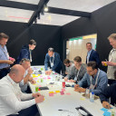
Jeroen Veger,
Additive Manufacturing
at 3DMZ,
posted
Modular Construction
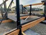
During this Meetup we will discuss how modular construction with wood and steel transforms traditional construction practices and opens new doors for efficiency, sustainability and creativity. The project team of the project “Modular and c
Circular Bridge Systems” will show the results of this project and would like to discuss the challenges that modular construction brings with it in the areas of creativity versus standardization, digitalization, circular materials and new business models.
Modular and industrial construction is an umbrella term for innovative construction methods that promote efficiency and sustainability. In modular construction, structures are built from prefabricated modules or components that are produced in a factory and then assembled on the construction site. This speeds up construction time and minimizes waste. Industrial construction focuses on advanced manufacturing technologies and standardized processes to improve quality and efficiency, while also offering flexibility in design. Both approaches contribute to cost savings, reduced environmental impact and faster project delivery in the construction sector.
The project team that will give the presentation consists of:
Thijs Asselbergs - Thijs Asselbergs Architectuurcentrale
Arjan Karssen - Bureau Arjan Karssen
Anke Rolvink - Packhunt
Jasper Dol - 3D Makers Zone (3DMZ)
Mark Feijen - Isaac
Chris Aerts - AplusV
Annette Beerepoot - BouwLab R&Do
16:00 - 18:00 | BouwLab - Oudeweg 91-96, Haarlem
Herman van den Bosch,
professor in management development
,
posted
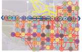
20. Facilities within walking and cycling distance
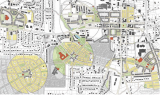
This is the 20th episode of a series 25 building blocks to create better streets, neighbourhoods, and cities. Its topic is to enable citizens having daily necessities in a walking and bicycling distance.
During the pandemic, lockdowns prevented people from leaving their homes or moving over a longer distance. Many citizens rediscovered their own neighbourhood. They visited the parks every day, the turnover of the local shops increased, and commuters suddenly had much more time. Despite all the concerns, the pandemic contributed to a revival of a village-like sociability.
Revival of the ‘whole neighbourhood’
Revival indeed, because until the 1960s, most residents of cities in Europe, the US, Canada, and Australia did not know better than their dally needs were available within a few minutes' walk. In the street where I was born, there were four butchers, four bakers, three greengrocers and four groceries, even though the street was not much longer than 500 meters. No single shop survived. My primary school was also on that street, and you had to be around the corner for the doctor. This type of quality of life went lost, in the USA in particular. However, urban planners never have forgotten this idea. In many cities, the pandemic has turned these memories into attainable goals, albeit still far removed from reality. Nevertheless, the idea of the 'whole neighborhood' gained traction in many cities. It fits into a more comprehensive planning concept, the 15-minute city.
Support for facilities
The idea is that residents can find all daily needs within an imaginary circle with an area of approximately 50 hectares. This implies a proportionate number of residents. A lower limit of 150 residents per hectare is often mentioned, considering a floor area of 40% for offices and small industry. The idea is further that most streets are car-free and provide plenty of opportunity for play and meeting.
Opportunity for social contacts
In a 'whole neighbourhood', residents find opportunity for shopping and meeting from morning to evening. There is a supermarket, a bakery, a butcher, a greengrocer's shop, a drugstore, a handful of cafes and restaurants, a fitness center, a primary school, a medical center, craft workshops, offices, green spaces and a wide variety of houses. Here, people who work at home drink their morning coffee, employees meet colleagues and freelancers work at a café table during the quiet hours. Housemen and women do their daily shopping or work out in the gym, have a chat, and drink a cup of tea. People meet for lunch, dinner and socializing on the terrace or in the cafes, until closing time. A good example is the Oostpoort in Amsterdam, albeit one of the larger ones with a station and a few tram lines.
Planning model
On the map above, the boundaries of the neighborhoods with an area of approximately 50 hectares are shown in the form of circles. The circular neighborhood is a model. This principle can already play a role on the drawing board in new neighborhoods to be built. In existing neighbourhoods, drawing circles is mainly a matter of considering local data. The center of the circle will then often be placed where there are already some shops. Shops outside the intended central area can be helped to move to this area. Spaces between existing homes can be reserved for small-scale businesses, schools, small parks, communal gardens and play facilities. Once the contours have been established, densification can be implemented by choosing housing designs that align to the character of the neighbourhood. Towards the outside of the imaginary circle, the building density will decrease, except at public transport stops or where circles border the water, often an ideal place for higher buildings.
If a thoroughfare passes through the center of the circle, this street can be developed into a city street, including a public transport route. Facilities are then realized around a small square in the center of the circle and the surrounding streets.
Incidentally, space between the circles can be used for through traffic, parks, and facilities that transcend districts, for instance a swimming pool or a sports hall or an underground parking garage. Mostly, neighborhoods will merge seamlessly into each other.
It will take time before this dream comes true.
Follow the link below to find an overview of all articles.
Harmen van Sprang,
co-founder & CEO Sharing Cities Alliance
,
posted
AI & The City

Join us on 28 September to explore how (generative) AI will impact our cities and change the way we live, work & play.
From livability to sustainability, from health/wellbeing to public safety, from transportation to infrastructure, and from economic opportunities to urban planning: there are many opportunities ahead (and already happening).
From ethical implications to regulation, from awareness to safety/trust, and from data quality to technological infrastructure: we also got plenty of challenges to address and overcome.
Like to join this virtual roundtable session on 28 September? Visit http://sharingcitiesalliance.com/events to sign up (for free).
We welcome you to already share your ideas, cases as well as concerns regarding (generative) AI via LinkedIn.
AI & The City is an initiative of the Sharing Cities Alliance & Studio Sentience.
Herman van den Bosch,
professor in management development
,
posted
9. Road safety
This is the 9th episode of a series 25 building blocks to create better streets, neighbourhoods, and cities. Casualties in traffic are main threats to the quality of the living environment. ‘Vision zero’ might change this.
Any human activity that annually causes 1.35 million deaths worldwide, more than 20 million serious injuries, damage of $1,600 billion and is a major cause of global warming would be banned immediately. Except for the use of the car. This post describes how changes in road design will improve safety.
The more public transport, the safer the traffic
Researchers from various universities in the US, Australia and Europe have studied the relationship between road pattern, other infrastructure features and road safety or its lack. They compared the road pattern in nearly 1,700 cities around the world with data on the number of accidents, injuries, and fatalities. Lead researcher Jason Thompsonconcluded: <em>It is quite clear that places with more public transport, especially rail, have fewer accidents</em>. Therefore, on roads too public transport must prioritized.
The growing risk of pedestrians and cyclists
Most accidents occur in developing and emerging countries. Road deaths in developed countries are declining. In the US from 55,000 in 1970 to 40,000 in 2017. The main reason is that cars always better protect their passengers. This decrease in fatalities does not apply to collisions between cars and pedestrians and cyclists, many of which are children. Their numbers are increasing significantly, in the US more than in any other developed country. In this country, the number of bicycle lanes has increased, but adjustments to the layout of the rest of the roads and to the speed of motorized traffic have lagged, exposing cyclists to the proximity of speeding or parking cars. SUVs appear to be 'killers'and their number is growing rapidly.
Safe cycling routes
In many American cities, paint is the primary material for the construction of bike lanes. Due to the proximity of car traffic, this type of cycle routes contributes to the increasing number of road deaths rather than increasing safety. The Canadian city of Vancouver, which doubled the number of bicycle lanes in five years to 11.9% of all downtown streets, has the ambition to upgrade 100% of its cycling infrastructure to an AAA level, which means safe and comfortable for all ages and abilities. Cycle paths must technically safe: at least 3 meters wide for two-way traffic; separated from other traffic, which would otherwise have to reduce speed to less than 30 km/h). In addition, users also need to feel safe.
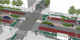
Street design
Vision Zero Cities such as Oslo and Helsinki are committed to reducing road fatalities to zero over the next ten years. They are successful already now: There were no fatalities in either city in 2019. These and other cities use the Vision Zero Street Design Standard, a guide to planning, designing, and building streets that save lives.
Accidents are often the result of fast driving but are facilized by roads that allow and encourage fast driving. Therefore, a Vision Zero design meets three conditions:
• Discouraging speed through design.
• Stimulating walking, cycling and use of public transport.
• Ensure accessibility for all, regardless of age and physical ability (AAA).
The image above shows a street that meets these requirements. Here is an explanation of the numbers: (1) accessible sidewalks, (2) opportunity to rest, (3) protected cycle routes, (4) single lane roads, (5) lanes between road halves, (6) wide sidewalks, (7) public transport facilities, (8) protected pedestrian crossings, (9) loading and unloading bays, (10) adaptive traffic lights.
Enforcement
Strict rules regarding speed limits require compliance and law enforcement and neither are obvious. The Netherlands is a forerunner with respect to the infrastructure for bikes and pedestrians, but with respect to enforcement the country is negligent: on average, a driver of a passenger car is fined once every 20,000 kilometers for a speeding offense (2017 data). In addition, drivers use apps that warn of approaching speed traps. Given the risks of speeding and the frequency with which it happens, this remissing law enforcement approach is unacceptable.
Follow the link below to find an overview of all articles.
Herman van den Bosch,
professor in management development
,
posted
8. Polycentricity
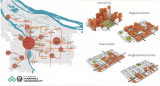
This is the 8th episode of a series 25 building blocks to create better streets, neighbourhoods, and cities. The question is whether a distribution of services over the whole area contributes to the quality of the urban environment.
The central parts of cities like Siena, Amsterdam and Barcelona are overrun by visitors and tourists. Partly because Airbnb has increased its overnight capacity by withdrawing homes from their actual destination. As a result, these cities see their real estate prices rise ans residents leave, making room for expensive apartments, boutique hotels and corporate headquarters. Eventually, old city centers will become amusement parks that offer twenty-four hours of entertainment.
The need for distributed centers
There are no objections against visiting nice cities. The underlying problem is that many of these cities have few other places of interest left, partly due to destruction in the Second World War and their rapid expansion afterwards. Therefore, some cities are in urgent need to create additional attractive places and become polycentric. This aligns with the intention of cities to become a 15-minute city. The figure above is a model developed for this purpose by the council of Portland (USA).
Because of this policy, the prospect is that residents can buy their daily necessities close to home. At the other hand, tourists will be spread. What attractive neighborhood centers look like will be discussed in a subsequent post.
Ancillary centers
Cities without an inordinate number of tourists and visitors also observe a steady grow in the number of events, all competing for the same locations. For this reason, it is advisable that cities have a few ancillary centers each with one or two crowd pullers that divide the stream of visitors. An example is the Guggenheim Museum in Bilbao and its newly developed public space around. In world cities such as London and New York, such centers have existed for years, but they are sometimes difficult to find because they are spread over a large area.
Amsterdam too urgently needs one or more ancillary centers. The area between Leidseplein and the Rijksmuseum has potential but lacks unity due to the chaotic intersections of roads and tram lines. The presence of a train or metro station is an advantage, that is why the area near Station Zuid also has potential.
Peripheral centers
Next decade, many visitors will still arrive by car and the best policy is to seduce them to leave their cars at safe transfer points to continue their journey by public transport. For visitors who intend to stay longer, this solution is not optimal. Many will dismiss the perspective of carrying their luggage to the hotel by public transport, although taking a cab is an alternative, albeit expensive. The alternative is the presence of a couple of affordable hotels next to the car park and the development of these areas into attractive public space, with shops, cafes, and restaurants, as a starting point to visit places of interest in the city. These centers can also accommodate major events, such as a football stadium, a music hall, cinemas and open-air festivities, because of the presence of large scale parking facilities. The Amsterdam Arena district is developing in this direction. It used to be a desolate place, but it's getting better. There are excellent train and metro links.
And what about the old 'old' city center?
The public spaces in the old city centers must meet the same requirements as the whole city to prevent becoming an amusement park for tourists. Aside from its carefully maintained and functionally integrated cultural legacy, centers should provide a mix of functions, including housing, offices, spaces for craft and light industry and plenty of greenery dedicated to its inhabitants. The number of hotels should be limited and renting out by Airbnb prohibited. There will be shops for both residents and tourists, rents must be frozen, and the speculative sale of houses curbed. Space over shops must be repurposed for apartments.
Follow the link below to find an overview of all articles.
https://www.dropbox.com/scl/fi/x39qvzkw687rxsjvhsrzn/overzicht-blogposts-Eng.docx?rlkey=vpf7pwlfxkildpr9r062t5gf2&dl=0
Beth Massa,
Ozarka B.V.
,
posted
We urgently need to rent your "wasstraat" and commercial dishwashers or sublease your space to build our own!
Hi All,
Since 2018, Ozarka works every variety of vendor or restaurant replacing disposable food containers with reusables, big or small, doesn't matter. As you can imagine, we are growing like crazy.
Our wash and sanitation model is decentralized. We have one main wash and sanitation facility called the "Sparkle Jar." We install "outposts" or mini-sparkle jars for wash and sanitation rather than build out more huge facilities. There are a variety of reasons for this (all good, more sustainable, and more affordable for our clients).
We need a lot more of these mini centers. SJ3, SJ4, SJ5...you get the idea. We are looking for partners that have the same commercial dishwashers we have that are not used very often Think office canteens, corporate food courts, hotels. Or, do you have water hookups and extra space that is not being used that we can rent out from you?
The most ideal locations are sort of on the outskirts of the centrum but still inside the A10. Hemshaven or Veemkade area...Oost, West, Noord are ideal locations.
The reuse revolution is really starting to take off! Our growth is going straight up and we need the Amsterdam Smart City community to help us expand our logistics by tapping into infrastructure that already exists.
Jorrit Saaltink,
Project Manager
at Amsterdam Trade,
posted
Sign up for Smart City Barcelona updates

Amsterdam trade & Innovate is a member of Trade & Innovate NL that organizes trade missions for entrepreneurs from the Amsterdam Region (MRA).
In november Barcelona Smart City takes place with a special focus on mobility.
Sign up through this link to be included in the updates of the program!
Want to know even more?
Email Jorrit Saaltink, trade developer mobility: j.saaltink@amsterdam.nl
Stay up to date
Get notified about new updates, opportunities or events that match your interests.
Set up preferences

