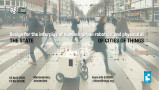
Traffic fatalities are a leading cause of premature death of people under 30. Most are pedestrians and cyclists. The question is how to redesign traffic to reduce the number of victims. Zero cities successfully do. Read my newest blogpost (in Dutch). The English version will be published in due time at Smart City Hub.
Want to receive updates like this in your inbox?
Get notified about new updates, opportunities or events that match your interests.
Maybe you will also like these updates
AI & The City

Join us on 28 September to explore how (generative) AI will impact our cities and change the way we live, work & play.
From livability to sustainability, from health/wellbeing to public safety, from transportation to infrastructure, and from economic opportunities to urban planning: there are many opportunities ahead (and already happening).
From ethical implications to regulation, from awareness to safety/trust, and from data quality to technological infrastructure: we also got plenty of challenges to address and overcome.
Like to join this virtual roundtable session on 28 September? Visit http://sharingcitiesalliance.com/events to sign up (for free).
We welcome you to already share your ideas, cases as well as concerns regarding (generative) AI via LinkedIn.
AI & The City is an initiative of the Sharing Cities Alliance & Studio Sentience.
9. Road safety

This is the 9th episode of a series 25 building blocks to create better streets, neighbourhoods, and cities. Casualties in traffic are main threats to the quality of the living environment. ‘Vision zero’ might change this.
Any human activity that annually causes 1.35 million deaths worldwide, more than 20 million serious injuries, damage of $1,600 billion and is a major cause of global warming would be banned immediately. Except for the use of the car. This post describes how changes in road design will improve safety.
The more public transport, the safer the traffic
Researchers from various universities in the US, Australia and Europe have studied the relationship between road pattern, other infrastructure features and road safety or its lack. They compared the road pattern in nearly 1,700 cities around the world with data on the number of accidents, injuries, and fatalities. Lead researcher Jason Thompsonconcluded: <em>It is quite clear that places with more public transport, especially rail, have fewer accidents</em>. Therefore, on roads too public transport must prioritized.
The growing risk of pedestrians and cyclists
Most accidents occur in developing and emerging countries. Road deaths in developed countries are declining. In the US from 55,000 in 1970 to 40,000 in 2017. The main reason is that cars always better protect their passengers. This decrease in fatalities does not apply to collisions between cars and pedestrians and cyclists, many of which are children. Their numbers are increasing significantly, in the US more than in any other developed country. In this country, the number of bicycle lanes has increased, but adjustments to the layout of the rest of the roads and to the speed of motorized traffic have lagged, exposing cyclists to the proximity of speeding or parking cars. SUVs appear to be 'killers'and their number is growing rapidly.
Safe cycling routes
In many American cities, paint is the primary material for the construction of bike lanes. Due to the proximity of car traffic, this type of cycle routes contributes to the increasing number of road deaths rather than increasing safety. The Canadian city of Vancouver, which doubled the number of bicycle lanes in five years to 11.9% of all downtown streets, has the ambition to upgrade 100% of its cycling infrastructure to an AAA level, which means safe and comfortable for all ages and abilities. Cycle paths must technically safe: at least 3 meters wide for two-way traffic; separated from other traffic, which would otherwise have to reduce speed to less than 30 km/h). In addition, users also need to feel safe.
Street design
Vision Zero Cities such as Oslo and Helsinki are committed to reducing road fatalities to zero over the next ten years. They are successful already now: There were no fatalities in either city in 2019. These and other cities use the Vision Zero Street Design Standard, a guide to planning, designing, and building streets that save lives.
Accidents are often the result of fast driving but are facilized by roads that allow and encourage fast driving. Therefore, a Vision Zero design meets three conditions:
• Discouraging speed through design.
• Stimulating walking, cycling and use of public transport.
• Ensure accessibility for all, regardless of age and physical ability (AAA).
The image above shows a street that meets these requirements. Here is an explanation of the numbers: (1) accessible sidewalks, (2) opportunity to rest, (3) protected cycle routes, (4) single lane roads, (5) lanes between road halves, (6) wide sidewalks, (7) public transport facilities, (8) protected pedestrian crossings, (9) loading and unloading bays, (10) adaptive traffic lights.
Enforcement
Strict rules regarding speed limits require compliance and law enforcement and neither are obvious. The Netherlands is a forerunner with respect to the infrastructure for bikes and pedestrians, but with respect to enforcement the country is negligent: on average, a driver of a passenger car is fined once every 20,000 kilometers for a speeding offense (2017 data). In addition, drivers use apps that warn of approaching speed traps. Given the risks of speeding and the frequency with which it happens, this remissing law enforcement approach is unacceptable.
Follow the link below to find an overview of all articles.
8. Polycentricity

This is the 8th episode of a series 25 building blocks to create better streets, neighbourhoods, and cities. The question is whether a distribution of services over the whole area contributes to the quality of the urban environment.
The central parts of cities like Siena, Amsterdam and Barcelona are overrun by visitors and tourists. Partly because Airbnb has increased its overnight capacity by withdrawing homes from their actual destination. As a result, these cities see their real estate prices rise ans residents leave, making room for expensive apartments, boutique hotels and corporate headquarters. Eventually, old city centers will become amusement parks that offer twenty-four hours of entertainment.
The need for distributed centers
There are no objections against visiting nice cities. The underlying problem is that many of these cities have few other places of interest left, partly due to destruction in the Second World War and their rapid expansion afterwards. Therefore, some cities are in urgent need to create additional attractive places and become polycentric. This aligns with the intention of cities to become a 15-minute city. The figure above is a model developed for this purpose by the council of Portland (USA).
Because of this policy, the prospect is that residents can buy their daily necessities close to home. At the other hand, tourists will be spread. What attractive neighborhood centers look like will be discussed in a subsequent post.
Ancillary centers
Cities without an inordinate number of tourists and visitors also observe a steady grow in the number of events, all competing for the same locations. For this reason, it is advisable that cities have a few ancillary centers each with one or two crowd pullers that divide the stream of visitors. An example is the Guggenheim Museum in Bilbao and its newly developed public space around. In world cities such as London and New York, such centers have existed for years, but they are sometimes difficult to find because they are spread over a large area.
Amsterdam too urgently needs one or more ancillary centers. The area between Leidseplein and the Rijksmuseum has potential but lacks unity due to the chaotic intersections of roads and tram lines. The presence of a train or metro station is an advantage, that is why the area near Station Zuid also has potential.
Peripheral centers
Next decade, many visitors will still arrive by car and the best policy is to seduce them to leave their cars at safe transfer points to continue their journey by public transport. For visitors who intend to stay longer, this solution is not optimal. Many will dismiss the perspective of carrying their luggage to the hotel by public transport, although taking a cab is an alternative, albeit expensive. The alternative is the presence of a couple of affordable hotels next to the car park and the development of these areas into attractive public space, with shops, cafes, and restaurants, as a starting point to visit places of interest in the city. These centers can also accommodate major events, such as a football stadium, a music hall, cinemas and open-air festivities, because of the presence of large scale parking facilities. The Amsterdam Arena district is developing in this direction. It used to be a desolate place, but it's getting better. There are excellent train and metro links.
And what about the old 'old' city center?
The public spaces in the old city centers must meet the same requirements as the whole city to prevent becoming an amusement park for tourists. Aside from its carefully maintained and functionally integrated cultural legacy, centers should provide a mix of functions, including housing, offices, spaces for craft and light industry and plenty of greenery dedicated to its inhabitants. The number of hotels should be limited and renting out by Airbnb prohibited. There will be shops for both residents and tourists, rents must be frozen, and the speculative sale of houses curbed. Space over shops must be repurposed for apartments.
Follow the link below to find an overview of all articles.
https://www.dropbox.com/scl/fi/x39qvzkw687rxsjvhsrzn/overzicht-blogposts-Eng.docx?rlkey=vpf7pwlfxkildpr9r062t5gf2&dl=0