The PICO project will help facilitate decision-making, from policy making till investment decision (of individual residents).
Partners


The PICO project will help facilitate decision-making, from policy making till investment decision (of individual residents).
Stakeholders still lack insights in the big picture about opportunities in residential areas to save energy and produce energy sustainably. It is unclear for municipalities, residents and other stakeholders which solutions are preferable, and what the costs and benefits amount to. However, this insight helps the coordination of policy; it makes residents and investors more aware and helps them focus on the future benefits of solutions, while reducing uncertainties.
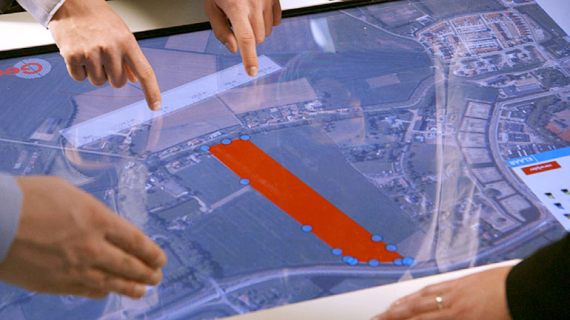
In this project, partners will design and build a tool in a GIS (Geographic Information System) that will already beforehand show as many aspects of a sustainability project as possible. The PICO project will help facilitate decision-making, from policy making till investment decision (of individual residents). It will work as a communication tool between different stakeholders in a renovation project of neighbourhoods and larger areas.
The functionality and application of the PICO tool we wish to demonstrate in a number of pilot programmes. Initially, three locations have been appointed: Amsterdam Nieuw-West (coordinator: Alliander), VU Campus Amsterdam (coordinator: Ecofys) and the De Kroeten neighbourhood in Breda (coordinator: Waifer). In these pilots, the wishes and needs of residents and owners of buildings play an important role, so PICO is designed with this in mind. In future, PICO can be used for other pilot projects.
PICO must connect large amounts of recent data from different sources, must process the data into clear representations according to the stakeholders’ wishes in area development, and must dynamically process these representations on different levels, from an individual home to an area. This way, PICO directly shows the effects of interventions; eventually it will export the results to a summary report.
TNO, Waifer, Ecofys, Esri, Liander, Alliander, Geodan